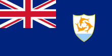
ANGUILLA
 Located 8km north of St Martin / Sint Maarten, Anguilla’s area is 91 sq km. With its small islands such as Sombrero Island, Scrub Island, Dog Island, Sandy Island, Anguillita Island, Seal Island and Prickly Pear Cays, its whole territory is 155 sq km. The relief is quite flat. Crocus Hill (65 m high) is the highest point. Anguilla has a dry vegetation. Many salt marshes attrack many migrant birds like egrets, herons and stilts.
From the 1980’s, tourism has taken an important part in the economy of the island (three-quarters of the Anguillians are employed in tourism) as the financial offshore. Fishing (fishes, lobsters etc…) and construction of boats are practized too.
Over 3500 years ago, Anguilla was an important place of settlement for the Arawak Indians according to the archeological excavations. Their villages were in Rendez-Vous, Island Harbour, Sandy Ground and Meads Bay. Then, the Carib Indians chased out the Arawaks and named the island “Malliouhana” (Arrow shaped).
In 1493, Christopher Columbus sighted Anguilla, named it Anguilla but he did not land on the island.
In 1650, the first European settlers who arrived in Anguilla were English people from St Christopher, today St Kitts. Most of them were pirates or bouccaneers. The island was incorporated into St Christpher or Antigua. Because of the drought, they did not found vast plantations but the island exported tabacco, cotton and salt.
Despite the French attempts to conquer it in 1745 and 1796, Anguilla stayed British.
In 1967, England decided to form a federation with Anguilla, St Christopher and Nevis. Because they considered that they were neglected and they did not want to be controled by the Kittitians, the Anguillians rebeled on May 30 and rose up in arms to chase out St Kitts’ police. After 85 years, on June 16, Anguilla left the colony made up of St Christopher and Nevis. In January, 1969, a referendum even was held and Anguilla’s independence was proclaimed. Great Britain did not accept this decision and it sent, on March 19, the Royal Navy to cruise in Anguilla’s territorial waters.
In the end, British army invaded Anguilla without any resistance. However, it was only in 1980 that England gave a clear status to Anguilla when it recognized its official separation from St Christopher.
According to the 1982 Constitution, Anguilla is a British overseas territory and belongs to the Commonwealth. A governor appointed by the Queen Elizabeth II leads the island with an appointed Executive Council and an elected Anguilla House of Assembly.
Area : 155 sq km (60 sq miles)
Population : 16 000 inhabitants
Capital : The Valley
Language : English
Currency : Eastern Caribbean Dollar (EC$)
People : Anguillians
