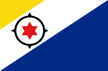
BONAIRE
 As Aruba and Curaçao, Bonaire is situated in about 20km from Venezuela in the Caribbean Sea. The island is flat, its highest point is Brandaris (241 m) ; its area is 285 sq km. In Bonaire, drinking water mostly comes from desalination plants. Bonaire has an islet named Klein Bonaire (Small Island, in Dutch) located off the capital Kralendijk which is deserted and protected by the government.
In the north-west, there is the Washington Shagbaai National Park, founded in 1969, which includes almost 20% of the territory. It is an arid tropical area where grow cacti and live birds (flamingos, parrots…), reptiles (green iguanas…).
In the south, the soil is flat, dry and covered with salt ponds caused by the sea water’s evaporation. The sea becomes pink in this place. There is also the “Donkeys Sanctuary”. It is the offspring of donkeys which were used to collect and to transport the salt during the slavery period ; they are almost 500.
In the east, there is Lac Bay occupied by mangrove and flamingos.
The sea water is very rich. The coral reefs surround the island. Hundreds of species of fish swim in these warm waters. Bonaire is regarded as the “divers’ paradise” and it is often rewarded.
Bonaire’s Marine Park belongs to the UNESCO World Heritage. It is composed of almost 90% diving sites and includes the whole coast of the island to a depth of 60m.
Tourism and salt production are Bonaire’s main economic activities.
Bonaire was discovered (probably on September 6th) by Alonso de Ojeda and Amerigo Vespucci who claimed the island for the Spanish crown. When the Spaniards trod the soil of this land, it was inhabited by Arawak Indians who lived there for thousands of years. Around 1520, all these Amerindians disappeared because the settlers enslaved and sent them to work in mines elsewhere in the Spanish empire ; the others, probably, ran away, commited suicide or died because of the bad treatments or diseases as it happened in the other Caribbean islands. Today, there are a few Arawak inscriptions in isolated caves.
In 1636, the Dutch invaded the depopulated Bonaire. Today, a plaque in Wilhelmina Park honors Van Walbeeck, the island’s first Dutch Commander. In the late 1600’s, they imported thousands of slaves in the south end of Bonaire to collect salt in the ponds. These Africans worked in inhuman conditions. Between 1799 and 1816, Bonaire went through a confused period : the island was occupied by several European nations. In 1816, it returned back definitely to the Dutch.
In 1863, slavery was abolished and the salt production stopped. The ex slaves who became farmers lived simply with Dutch and people from South America.
After the Second World War, the salt factories reopended with machines to do the hard work. Tourism and diving developed.
On October 10, 2010, the Federation of the Netherlands Antilles stopped existing. Bonaire (like Saba and Sint Eustatius, two other Dutch islands in the Caribbean) decided to be governed directly by The Hague and not by Curaçao (the island-capital of the Netherland Antilles). It is a municipality of the Netherlands with a particular status so it has adjustments for its small area, its distance from the kingdom and its geographical situation in the Caribbean region. The Bonaireans have the Dutch nationality.
Bonaire : 285 sq km (110 sq miles)
Population : 17 400 inhabitants
Capital : Kralendijk
Language : Dutch – Papiamentu
Currency : Netherlands Antillean Guilder (NAf)
People : Bonaireans
