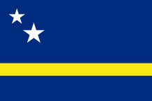
CURAÇAO
 Like Aruba and Bonaire, Curaçao is a Ducth island situated off the Venezolan coasts. With its 471 sq km, Curaçao is the largest island of the ABCs. Almost the two thirds of the population live in Willemstad, the capital.
The island is flat, arid and steep. There is no rivers on the island, water is produced by desalination plants however tap water is of good quality and can be drunk.
In the north (25km from Willemstad), is the Christoffel National Park which is 1800 hectares. It is composed of three old plantations of the country. The main – Landhuis Savonet – was built in 1662 by the Dutch West India Company. There are cacti, orchids, reptiles (iguanas…), birds (parrots…) and caves with Amerindian drawings.
In the east, the coast is windy, steep and not very developed.
In the south, the coast and the reefs are protected by the creation of the National Underwater Park where live hundreds of species of fish and several varieties of coral.
In the economy field, the major industries include tourism, oil and offshore banking. The first inhabitants in Curaçao were the Caiquetios Indians, a subgroup of the Arawak tribe which occupied this land approximately 6 000 tears ago. The island was discovered in 1499 by the Spanish explorer, Alonso de Ojeda, and the Italian explorer, Amerigo Vespucci.
Immediately, the colonists enslaved the peaceful Arawaks and sent them everywhere in the Spanish empire. Some of them were killed or committed suicide.
However, at the beginning of the 16th century, they concluded that this island had very few gold and not enough cool water to settle big farms then, they abandoned it. In 1634, the powerful Dutch West Indian Company seized this island and appointed governor the Dutch explorer Peter Stuyvesant, in 1642. The latter set up very quickly on the island big plantations which produced fruits, corns, poeanuts atc. ; salt was also gathered in the salty ponds by African captives.
About thirty years after the arrival of the Dutch colonists, Curaçao became ann important trade center (in particular slaves trade) due to its port in deep water and its coasts protected. Half the slaves sent to the Caribbean islands went through its markets.
Today, the wealth of the island at that time is confirmed by the old Willemstad’s architecture. In 1997, the UNESCO registered, moreover, on the list of the world heritage the historic center of the capital and the port of Curaçao.
The end of slavery in 1863 caused the economic decline of Curaçao so the growing of aloe and orange was tried. In the early 20th century, oil refineries to process Venezolan oil were constructed on the island.
In the political field, the island was self-governing since December 15, 1954 because of decolonization. Curaçao was the former island-capital of the Netherlands West Indies. On October 10, 2010, Curaçao (like Sint Maarten) gained the country status within the kingdom of the Netherlands and became very autonomous.
Area : 471 sq km (182 sq miles)
Population : 150 000 inhabitants
Capital : Willemstad
Languages : Dutch – Papiamentu
Currency : Netherlands Antillean Guilder (NAf)
People : Curaçaoans
